 Dinner under way versus Dinner at Anchor

The day started at 0600. We could see land on three sides so thought it best to leave our snug anchorage quickly before more fog settled in. We apparently were not quick enough. As soon as we turned from West to East, all sight of the rocks was gone. We slowly made our way via sight, sound and Garmin GPS as several reboots of the Raymarine left us without our chartplotter. Raymarine’s radar was kept up and running so at least we had a sense of less doom as the radar arm loomed over the rocky coast. We had abandoned our planned exit via the Dover Passage (depth minimum 12 feet, width minimum 60 feet) as we could not see more than 20 feet. Instead we went out the way we came in. Port Island in front, Black Rock on the left, Whale Shoal all around us. When sufficiently South, we turned East as I spent a good 45 minutes getting the electronics in useable form. But, if everything worked right we would be just like power boaters. No “adventure” in that.
At 1020 local time we are just now across the St. Peter’s Bay Traffic Separation Zone (Channel) which technically means we are out of Nova Scotia Island and at Cape Breton Island. Today’s stop is Louisbourg, population 1,261. Other than the multi-million dollar Fort Restoration, the CCA Guide has this to say: “lacks charm”, and “restaurants are of the beanery variety” (whatever that means!). We plan on a tourist day at the Fort and rest up for our 30 hour transit to Ste. Pierre. It is somewhat amazing that in less than a week we will be headed into a third country. Like the Caribbean, but without the Sun. And warm water. And rum drinks. And…..
1 comment:
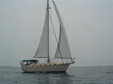
That is one sweet looking boat, I mean, er...vessel; mate! I want a ride. You got the life, Marts.
All is well here. Oil markets are volatile as ever...never a dull moment.
Happy sailing....or boating...or whatever you water lubbers say.
Say hello to Tess.
Rich
Post a Comment